


randogps81-348

CANON2
User
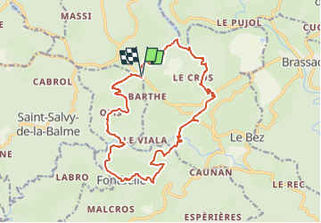

Length
19.4 km

Max alt
679 m

Uphill gradient
754 m
Km-Effort
29 km

Min alt
418 m

Downhill gradient
753 m
Boucle
Yes
Creation date :
2024-02-13 12:56:57.896
Updated on :
2024-02-13 13:00:07.657
6h42
Difficulty : Very difficult

FREE GPS app for hiking
 SityTrail
IGN / Geographical institutes
SityTrail Plus
The world is yours!
About
Trail Walking of 19.4 km to be discovered at Occitania, Tarn, Le Bez. This trail is proposed by CANON2.
Positioning
Country:
France
Region :
Occitania
Department/Province :
Tarn
Municipality :
Le Bez
Location:
Unknown
Start:(Dec)
Start:(UTM)
454504 ; 4830431 (31T) N.
Comments